


MORE areas in Luzon and Visayas have been placed under storm signals as Typhoon “Egay” further intensified while moving westward over the Philippine Sea, the state-run weather agency said on Monday.
Under Signal No. 2 are Catanduanes, central and eastern portion of Isabela (Palanan, Dinapigue, Santo Tomas, Cabagan, Tumauini, San Pablo, Maconacon, Santa Maria, Quezon, Delfin Albano, Mallig, Quirino, Roxas, Burgos, Ilagan City, Divilacan, San Mariano, Gamu, Naguilian, Benito Soliven, City of Cauayan, Reina Mercedes, Luna, San Manuel, Aurora, Cabatuan, San Guillermo, Echague, Jones, Angadanan, Alicia, San Mateo, San Isidro and San Agustin), eastern portion of Albay (Rapu-Rapu, Bacacay, City of Tabaco, Malilipot, Malinao and Tiwi), eastern portion of Camarines Sur (Caramoan, Presentacion, Garchitorena, Lagonoy, San Jose and Sag?ay), northern portion of Aurora (Dilasag, Casiguran and Dinalungan), eastern portion of Quirino (Maddela), eastern and central portion of Cagayan (Santa Ana, Gonzaga, Lal-Lo, Santa Teresita, Buguey, Gattaran, Baggao, Pe?ablanca, Amulung, Alcala, Iguig, Tuguegarao City, Solana and Enrile), and the northern portion of Camarines Norte (Calaguas and Maculabo Islands) in Luzon; the northeastern portion of Northern Samar (Laoang and Palapag) in the Visayas.
In an 11 a.m. advisory of the Philippine Atmospheric Geophysical and Astronomical Services Administration (Pagasa), Sorsogon, the rest of Albay, the rest of Camarines Sur, the rest of Camarines Norte, the rest of Isabela, the rest of Cagayispran including Babuyan Islands, Apayao, Abra, Kalinga, Mountain Province, Ifugao, the rest of Quirino, Nueva Vizcaya, Batanes, Masbate including Ticao Island, Burias Island, Quezon including Pollilo Islands, the rest of Aurora, Benguet, Ilocos Sur, Ilocos Norte, La Union, Nueva Ecija, Pangasinan, Tarlac, Zambales, Bulacan, Pampanga, Bataan, Marinduque, Cavite, Metro Manila, Rizal, Laguna, eastern and central portion of Romblon (Banton, Corcuera, Romblon, Magdiwang, Cajidiocan and San Fernando) and the northern and central portion of Batangas (Calaca, Cuenca, Taysan, Lian, Tuy, Balayan, Talisay, Padre Garcia, Agoncillo, Santo Tomas, San Jose, Lemery, Lipa City, Ibaan, City of Tanauan, Mataasnakahoy, Alitagtag, Balete, Nasugbu, San Juan, San Nicolas, Rosario, Laurel, Santa Teresita, Taal and Malvar) are now under Signal No. 1.
Also under the same storm signal in the Visayas are Eastern Samar, the rest of Northern Samar, Samar, Biliran, northern and central portion of Leyte (Tunga, Pastrana, San Miguel, Mahaplag, Matag-Ob, Tolosa, Palo, Calubian, Leyte, Mayorga, Julita, Carigara, Babatngon, Dagami, Jaro, Abuyog, San Isidro, Santa Fe, Albuera, Villaba, La Paz, Palompon, Macarthur, Tabontabon, Tanauan, Merida, Ormoc City, Isabel, Javier, Dulag, Capoocan, Alangalang, City of Baybay, Burauen, Tabango, Tacloban City, Kananga and Barugo) and the northern portion of Cebu (Daanbantayan and Medellin) including Bantayan Islands and Camotes Islands.
delivered to your inbox
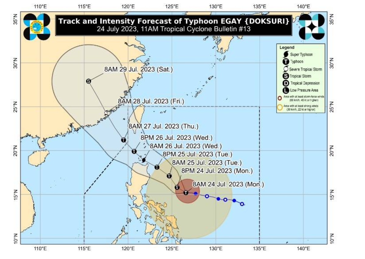
Pagasa said the center of the eye of the typhoon was at 525 kilometers east of Baler, Aurora.
Packing maximum sustained winds of 150 kilometers per hour (kph) near the center and gustiness of up to 185 kph, Egay is moving westward slowly, the latest advisory said.
Over the next 12 hours, the typhoon will likely track west-northwestward before turning northwestward and head closer to the landmass of Northern Luzon towards the Luzon Strait.
“On the track forecast, this typhoon is forecast to cross the Luzon Strait and make landfall or pass very close to the Babuyan Islands-Batanes area between late Tuesday evening and Wednesday afternoon,” Pagasa said.
It explained that further shift in the track forecast closer to Luzon remains a possibility due to the persistence of the ridge of high pressure north of the typhoon.
“As such, a landfall over the northeastern portion of mainland Cagayan is not ruled out,” Pagasa said.
Egay is forecast to intensify further and may reach super typhoon category by late Tuesday or early Wednesday.
Egay may exit the Philippine Area of Responsibility on Thursday, the state weather bureau said.


