")


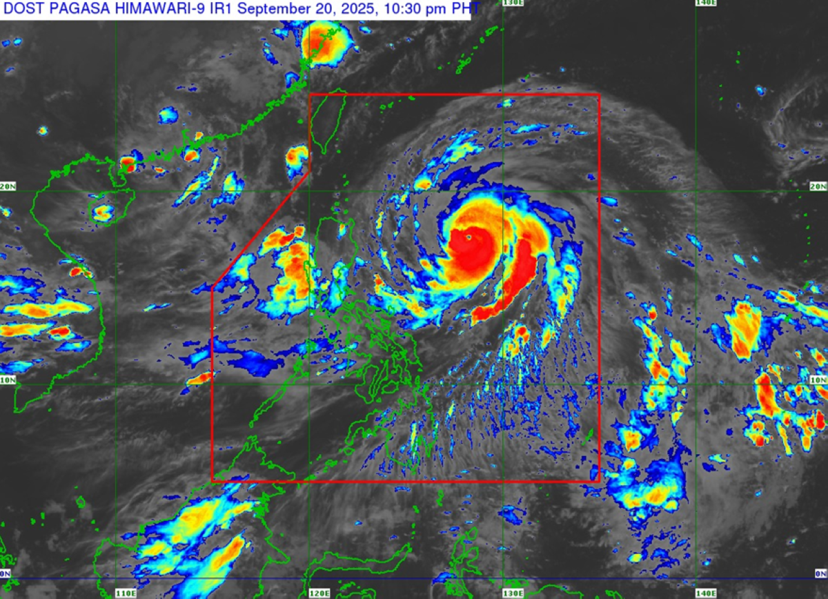
MANILA, Philippines – At least four provinces in Northern Luzon have been placed under Signal No. 2 due to Tropical Cyclone Nando, which is seen to further intensify into a super typhoon anytime within the day, the state-run weather agency said on Sunday.
Weather specialist Robert Badrina of the Philippine Atmospheric Geophysical and Astronomical Services Administration (Pagasa) said that areas under Signal No. 2 include Batanes, Cagayan including Babuyan Islands, the northeastern portion of Isabela (San Mariano, Ilagan City, Tumauini, Cabagan, Palanan, Divilacan, Maconacon, San Pablo, Santa Maria, Santo Tomas and Delfin Albano), the eastern portion of Apayao (Luna, Santa Marcela, Pudtol and Flora), and the eastern portion of Kalinga (Rizal).
Under Signal No. 1 were the rest of Isabela, Quirino, Nueva Vizcaya, the rest of Kalinga, the rest of Apayao, Abra, Mountain Province, Ifugao, Benguet, Ilocos Norte, Ilocos Sur, La Union, Pangasinan, the northern portion of Zambales (Santa Cruz, Candelaria, Masinloc and Palauig), the northern and central portions of Nueva Ecija (Carranglan, Lupao, San Jose City, Pantabangan, Bongabon, Laur, Gabaldon, General Mamerto Natividad, Rizal, Llanera, Talavera, Science City of Muñoz, Santo Domingo, Talugtug, Palayan City, Cuyapo, Nampicuan, Guimba, Licab, Quezon, Aliaga, Cabanatuan City, Santa Rosa, Zaragoza, Jaen, San Leonardo, General Tinio and Peñaranda), the northern and central portions of Tarlac (San Jose, City of Tarlac, La Paz, Victoria, Gerona, Paniqui, Moncada, San Manuel, Anao, Ramos, Pura, Camiling, San Clemente, Mayantoc, Santa Ignacia), Aurora, and the northern and central portions of Catanduanes (Pandan, Caramoran, Bagamanoc, Panganiban, Viga, Gigmoto, San Miguel and Baras)
Estimated some 610 kilometers east of Tuguegarao City, Cagayan, Nando is moving northwestward at 15 kilometers per hour (kph), with maximum sustained winds of 175kph near the center and gustiness of up to 215kph, the national weather bureau said.
According to Pagasa, the typhoon may pass close or may make landfall over Batanes or Babuyan Islands between Monday afternoon and evening.
Seen to exit the Philippine Area of Responsibility by early Tuesday morning, Nando may reach super typhoon category on Sunday and will continue to intensify before it approaches extreme Northern Luzon, Pagasa’s Badrina said.
Meanwhile, the southwest monsoon or habagat would prevail over Metro Manila, Bicol Region, Zamboanga Peninsula, the rest of Visayas, the rest of CALABARZON (Cavite, Laguna, Batangas, Rizal and Quezon), and the rest of MIMAROPA (Mindoro, Marinduque, Romblon and Palawan) where cloudy skies with scattered rains and thunderstorms would be possible, the weather agency said.
The rest of Mindanao would be experiencing partly cloudy to overcast skies with isolated rain showers or thunderstorms also due to habagat, it added.
")