")

MANILA, Philippines – Super Typhoon “Nando” (international name: (Ragasa) continues to weaken after making landfall in Babuyan Islands and is expected to exit the Philippine Area of Responsibility (PAR) on Tuesday morning, according to the state weather bureau.
In its 5 a.m. briefing, the Philippine Atmospheric Geophysical and Astronomical Services Administration (Pagasa) said that Signal No. 3 was raised over Ilocos Norte, the northwestern portion of Apayao (Calanasan) and the northwestern portion of mainland Cagayan (Sanchez-Mira, Santa Praxedes and Claveria) including the western portion of Babuyan Islands (Panuitan Island, Calayan Island, Dalupiri Island, Mabaag Island, Barit Island and Fuga Island).
Pagasa administrator Nathaniel Servando said Signal No. 2 was still up over Batanes, the rest of Babuyan Islands, the northern and central portions of Cagayan (Iguig, Solana, Tuao, Baggao, Amulung, Piat, Santa Ana, Gattaran, Lal-Lo, Gonzaga, Pamplona, Abulug, Ballesteros, Aparri, Camalaniugan, Buguey, Santa Teresita, Allacapan, Lasam, Santo Niño, Alcala and Rizal), the rest of Apayao, Abra, Kalinga, the western portion of Mountain Province (Besao, Tadian, Sagada, Bauko, Sadanga, Bontoc and Sabangan), the northern portion of Benguet (Mankayan and Bakun), Ilocos Sur, and the northern portion of La Union (Sudipen, Bangar, Luna, Balaoan and Santol).
Meanwhile, the rest of Cagayan, Isabela, Quirino, Nueva Vizcaya, the northern and central portions of Aurora (Dilasag, Casiguran, Dinalungan, Dipaculao and Maria Aurora), the rest of Mountain Province, Ifugao, the rest of Benguet, the rest of La Union, Pangasinan, the northern portion of Zambales (Santa Cruz, Candelaria, Masinloc, Iba and Palauig), the northern and central portions of Tarlac (Paniqui, La Paz, Moncada, City of Tarlac, San Jose, Gerona, Mayantoc, Pura, San Clemente, Santa Ignacia, Victoria, Camiling, Ramos, San Manuel and Anao), and the northern and central portions of Nueva Ecija (Cuyapo, Talavera, Santo Domingo, Rizal, Zaragoza, Llanera, Guimba, Aliaga, Pantabangan, Science City of Muñoz, General Mamerto Natividad, Carranglan, Quezon, San Jose City, Lupao, Nampicuan, Talugtug, Licab and Bongabon) remain under Signal No. 1, the national weather agency said.
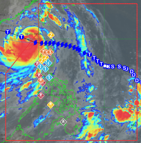
Estimated some 265 kilometers west of Calayan, Cagayan, the super typhoon is moving westward at 20 kilometers per hour (kph) while packing maximum sustained winds of 185kph near the center and gustiness of up to 230kph, it added.
Likely to move generally west-northwestward until it exits PAR, Nando will turn westward Wednesday towards southern China, Servando said.
On one hand, the southwest monsoon locally known as “habagat” continues to prevail over other areas particularly Metro Manila, Mimaropa (Mindoro, Marinduque, Romblon and Palawan), Calabarzon (Cavite, Laguna, Batangas, Rizal and Quezon), and the rest of Central Luzon where scattered rains and thunderstorms would prevail, the Pagasa chief said.

")